An Interview with Tony Agresta, Vice President of Marketing, Nearmap US
By Heidi J. Ellsworth, Partner RoofersCoffeeShop.com
A picture is worth a thousand words is very true, especially for roofing contractors as they try to differentiate themselves using technology.
One of the most disruptive technologies to hit the roofing industry in recent history is the use of aerial photography also known as aerial mapping. Having my own history working with this type of disruptive and important technology, I sat down with Tony Agresta, VP of Marketing for Nearmap US to find out more about what Nearmap is bringing to the market.
What is Nearmap’s history?
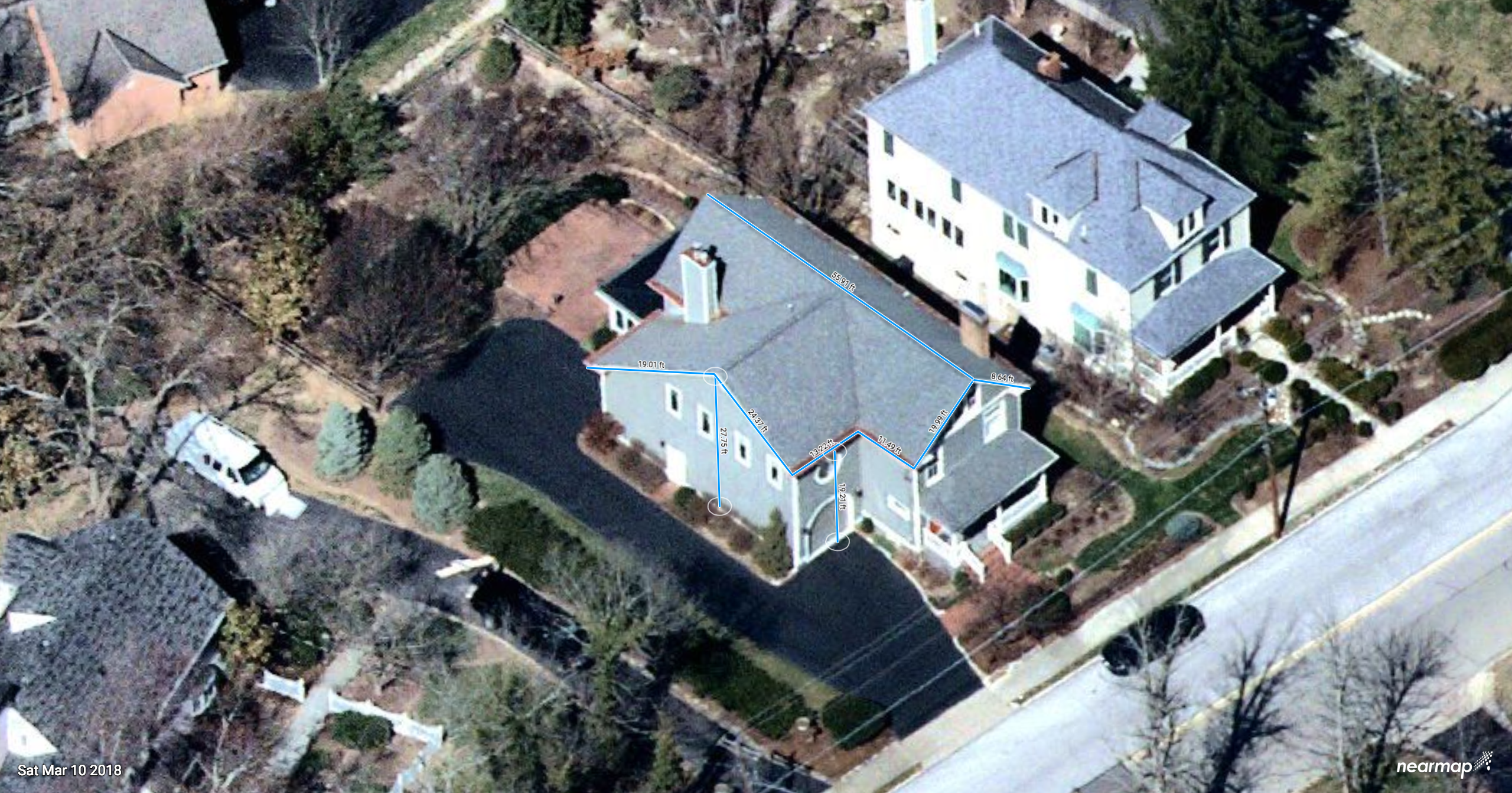
Nearmap has been in business since the fall of 2017. We started in Australia and today has over 87,000 users worldwide across 8500 organizations including both government and commercial. The US division is growing rapidly adding sales, marketing and operations at our headquarters in South Jordan, Utah and survey operations in Tysons Corner, Virginia. Our products include MapBrowser (accessible via a tablet or desktop) as well as APIs that allow users to embed our aerial maps in custom applications. MapBrowser is an easy way to locate commercial or residential properties, inspect the quality of the roof, analyze change over time, measure and export for use in proposals or quoting.
How often do you capture aerial imagery across the US?
Our first captures in the states were in the summer of 2014. We have currently captured 430 urbanized areas, 72% of the US population. We are focused on capturing these areas multiple times per year including both leaf-on and leaf-off aerials. Roofers can measure with precision without leaves on the trees while also seeing how close the leaves and trees are to the roof. With imagery since 2014, we have already gathered a substantial history of aerial captures and year-over-year changes. Users can quickly compare two dates in time, look at changes to the roof and deploy their sales and service teams accordingly.
What are some of the difficulties in capturing good aerial imagery year-round?
We have developed a very consistent capture program using a highly efficient fleet of planes and image processing software allowing us to deliver the imagery in the cloud days after capture. Some locations – for example the upper mid-west- have short periods of time to capture “leaf off” imagery after the snow melts but before the leaves come out. We’ve been successful in these geographies and closely monitor weather conditions constantly. Our cameras and fleet of planes systematically move across the country as we build our historical archive. Customers love the consistency of the imagery, year-over-year.
How are contractors using the imagery?
In our recent webinar on the Coffee Shop, we showed how contractors are using aerial imagery throughout the entire roofing lifecycle. Starting with neighborhood marketing and prospecting to production planning and overall service documentation, contractors are using the imagery and resulting year-over-year change analysis to tell the story better than words. I would recommend watching the webinar since it includes a demo how our MapBrowser and actual use cases for roofers.
Do you integrate with any other software?
Yes, we feel it is very important to collaborate with our fellow technology providers. RoofSnap and ESRI, for example utilize our imagery. We do share the imagery space with drone captures but we have found that the contractors need both. Aerial imagery is scalable so that contractors can get imagery anywhere, anytime with very little wait time and very economically. It is critical for the speed of operations that the imagery and analytic tools that gather data are available to the end users 24/7.
What makes you different from other aerial imagery?
As we discussed, we have built a lot of consistency into our capture and delivery models. We don’t wait for customers to pay us to fly. We take a very structured, planned approach and capture all imagery in sub 3” GSD for over 330,000 square miles of the US. Our aerial maps are available in MapBrowser which anyone can learn in minutes. Users become very productive very quickly. It makes prospecting, measuring and data extraction very simple. You can switch between ortho (straight down) to oblique (angled perspectives) and then to panoramas, getting all the look angles you need. All the imagery is high resolution and current. We offer side-by-side change analysis for prospecting. Many roofers use the imagery to build quotes faster and resolve customer inquiries instantly. Utilizing the measuring tools and the various perspectives, contractors can also measure parapet and building heights which are crucial for commercial roofing contractors.
What are you doing for commercial roofing applications?
For commercial roofing, we really offer flexibility for commercial roofing estimators, sales and production. Using our imagery, they can measure heights including parapets, measure various parts of the roof as necessary, export files of roof drawings and save the map with or without measurements. It also offers a full view year-over-year of the property to help with ongoing service, maintenance and sales.
What is next?
Watch for Nearmap imagery to be delivered in 3D. We’ve captured 50% of the US in 3D as of today. With 3D, roofers will have the ability to immerse themselves inside the imagery and navigate through the landscape and properties.
For more information about Nearmap and to find out more about getting a FREE sample image please CLICK HERE
Nearmap is a member of Roofing Technology Think Tank (RT3), where we see the need for innovative technologies in the roofing space. We continue to see the need for accessing, high resolution imagery in these applications, so we know that incorporating aerial imagery into your roofing businesses will only lead you to greater innovation, flexibility and success that ultimately leads to greater profitability.










Comments
Leave a Reply
Have an account? Login to leave a comment!
Sign In