Hurricane Laura: Before and After the Catastrophe

By Nearmap.
Aerial imagery aids in recovery efforts for industries and public safety officials.
Nearmap planes were in the air shortly after Hurricane Laura passed along the Texas and Louisiana border. Aircraft were placed strategically outside of a known impact zone, capturing high-resolution aerial imagery before and after the catastrophe. The importance of these images should not be overlooked, as aerial imagery aids in recovery efforts and cleanup planning. Aerial imagery can also aid in public safety and enhance a company's ability to assess damages quickly. As environmental disasters continue to rise in frequency, aerial imagery could be a crucial tool for contractors and roofing companies everywhere.
But the imagery isn’t just for those helping aid in recovery and relief efforts. With damage from Hurricane Laura currently being estimated between $8 to $12 billion, insurers will need the ability to quickly assess and validate the destruction to improve claim management amid all the loss suffered by those on the ground.

Providing coverage beyond post-cat
Nearmap currently has an extensive, continually updated library of high-res pre- and post-cat aerial imagery covering the areas affected by Hurricane Laura—and not just for recent events. Nearmap has been capturing imagery in some of the impacted areas since 2016, providing a historical archive for public safety officials and others to easily compare pre- and post-storm environments.

Accessing this aerial content is made simple and efficient through MapBrowser, a web-based platform. All pre- and post-hurricane imagery captured by Nearmap is available via this web application with easy-to-use APIs for integration into common GIS, CAD and other applications.
Nearmap imagery is published at sub-3” (5.6-7.5cm) Ground Sampling Distance (GSD), which allows users to see great detail on the ground. At this resolution, they can clearly identify important ground conditions such as roof damage with missing shingles, structural deterioration, major property damage, and flooding. Utility companies can readily identify damage to utility poles, gauge proper access routes and plan transportation amidst the chaos. The same is true for streets and all other ground features, providing details for users to complete analysis both pre- and post-storms.
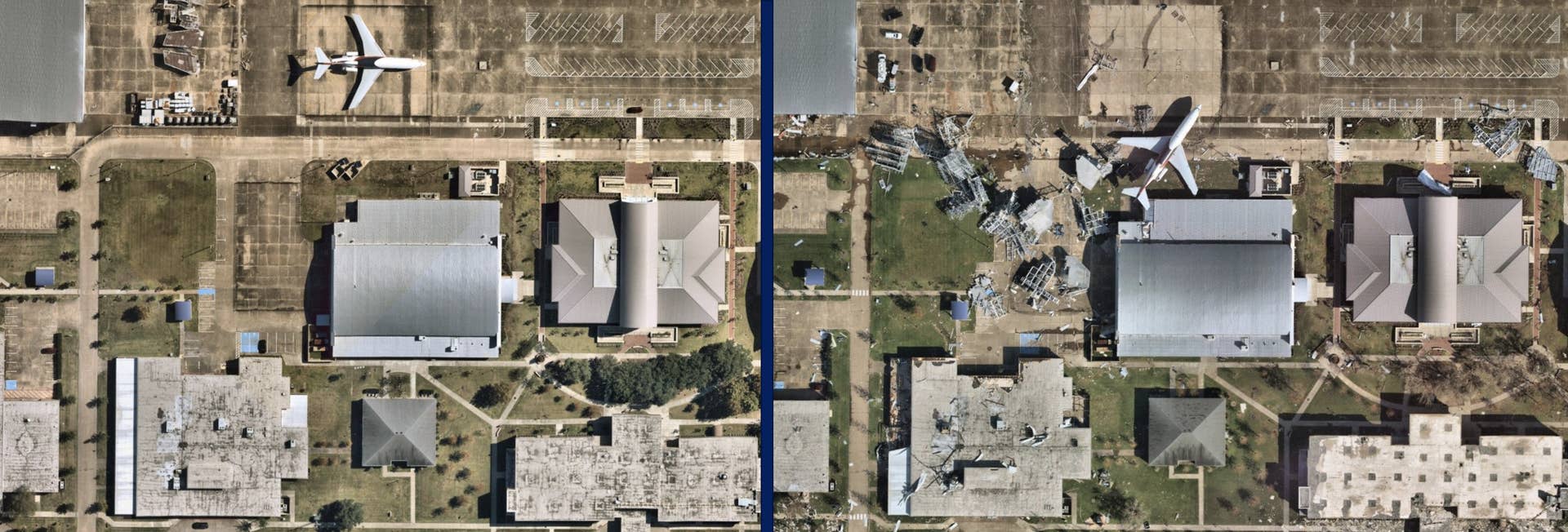
Beyond Hurricane Laura, we were able to capture post-cat imagery throughout August—from recent tornadoes in Cedar Rapids, IA, the Midwest derecho, and a portion of the wildfires in California (Hennessey Fire). All of the imagery captured can play an invaluable role in post disaster coordination and helping better prepare for future needs. The availability of post-hurricane imagery and future post-cat imagery within MapBrowser or APIs is subject to further conditions. For a more in-depth conversation on coverage, please contact a member of the Nearmap team by filling out the form at the top of this page, "Try Nearmap".
Learn more about Nearmap in their RoofersCoffeeShop® Directory.
Original article source: Nearmap




















Comments
Leave a Reply
Have an account? Login to leave a comment!
Sign In