Accelerate Your Roofing Business
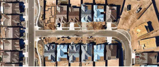
From initial inspection through final installation, high resolution aerial imagery speeds up your work process, reduces risk, enhances workforce productivity and adds to your bottom line.
Leverage both current and historical photos of your prospect rooftops to generate accurate estimates, lower material costs and exceed customer expectations.
Prospect – Identify new business from your desktop.
Interested in rapid business development without having to spend countless days on the road? Nearmap provides current, clear aerial imagery in the cloud. You can scan thousands of rooftops quickly – all from the comfort of your office. Using frequently updated high-resolution imagery, roofing estimators and installers get all the information they need to identify optimal prospects and create accurate quotes.
Estimate – Calculate costs with precision and propose your job in vivid detail.
Tired of the guesswork that comes with outdated aerial imagery? Does your current approach lack the clarity needed to get the job done? With PhotoMaps™ from Nearmap you get much better resolution than satellite imagery and dependable accuracy when measuring distances and calculating rooftop areas for customer estimates. Show damage that needs repair, or highlight their options to help upsell improvements.
Install – Plan with confidence and reduce material waste.
Roofing estimators don’t like surprises, and neither do installers when they run short on materials or end up with a wasteful surplus. When estimators have all the information they need, your bill-of-materials’ accuracy is greatly improved. Costly time delays with idle crews are also minimized. Plan with confidence using clear and timely imagery from Nearmap and keep your crews on-task doing what you’ve hired them to do: install, install, install.
Target new construction to build opportunities with homebuilders.
We regularly update imagery and deliver it to you within days of capture. Our historical archive and current imagery allow you to see change and identify new developments early in the construction life cycle. Observe when land is cleared, and open subcontractor negotiations with homebuilders earlier in their process. Current imagery helps you level the playing field and compete for new business.
Identify repair opportunities.
Our imagery is better than 2.8” GSD so you actually see temporary repairs that satellite images miss. And with multiple captures per year, you can act on that information immediately.
Nearmap integrates with popular design and estimation tools
The most current high-resolution imagery builds trust and confidence when your customers see what you say. Access is lightning fast from the cloud, and PhotoMaps™ integrates with AutoCAD® and takeoff software that adds another data layer. The bottom line? Streamline workflows, maximize workforce productivity and grow your business.
For more information about Nearmap and to find out more about getting a FREE sample image please CLICK HERE
















Comments
Leave a Reply
Have an account? Login to leave a comment!
Sign In