


-2.png "SOPREMA - Navigation Ad - The Right Coatings for the Right Roofs (On Demand)")


Aerial Imagery: The Proof is in the Roof

Advances in Aerial Imagery Allow Roofers to Reach New Heights.
Everywhere you look, technology is changing the way people work. Roofing is no exception. New forms of high resolution aerial photography now allow roofers to see details without sending people on site, scaling ladders and wasting time. Less risk, less resource, higher revenue.
The same wave of technology shining on construction, solar and a host of other industries is, in large part, due to instantly accessible, current imagery that users view from their desktop or tablet. How will this transform the way you roof? The impact is felt in all stages of the roofing project lifecycle and leads to faster, more nimble business operations. But before we discuss that angle, let’s see some proof.
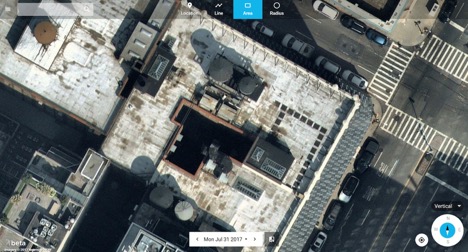
Here’s a random roof Nearmap spotted in the Big Apple. This perspective is a vertical, top down image of a building on East 31st Street. It’s shown inside of a cloud product called MapBrowser from Nearmap.
We’ve placed a few sample area measurements on the roof simply to point out examples where a trained roofer may want to focus repairs:
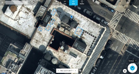
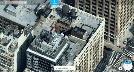
The vertical (ortho) imagery shown above helps roofers identify areas in need of repair, create proposals and allocate resources. But roofers may also want to easily navigate to what’s known as “oblique imagery” to show height and perspective. Obliques allow you to better understand how to navigate the space and tackle the challenges ahead. Here’s an example of the same building in an oblique form:
Now, here’s a lower resolution satellite image of the exact same roof:
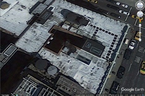
At first glance, they seem similar. But there are obvious differences as you analyze the imagery more closely. The date of the Google Earth image is 6/25/2016, well over a year ago. The aerial images from Nearmap were captured on July 31, 2017. With the Nearmap image, notice in the center left, darker areas of the roof that show aging probably due to wear and tear within the last twelve months. The older satellite imagery is fuzzy, shows less detail with respect to systems on the roof. The oblique imagery from Nearmap provides a unique vantage point showing elevation allowing roofers to better prepare for on-site detailed inspection and repair.
As you consider the full range of business operations in roofing, imagine high resolution photography supporting these areas:
- Lead Generation - instantly navigate from one location to another, thousands of locations per person, per day – all in support of identifying commercial and residential roofs in need of repair.
- Sales Enablement - quickly overlay street names and other locations on the high-resolution imagery, visual cues that help direct their sales team to the precise location.
- Proposal Development - export the imagery, include photos inside of detailed proposals and build confidence with their prospect base using the most current imagery on the market.
- Estimates and Quotes – Area, line, radius and height measurement including provide data to more accurately quote and estimate your jobs.
- Customer Service - As repairs take place, roofers can see change over time. Nearmap delivers three captures per year so you can keep an eye on your jobs.
The innovation does not stop here. For the roofing purists in need of blueprints, material ordering, project management and more, Nearmap aerial imagery has been integrated into RoofSnap, a fully functional platform that runs on Apple, Android and SketchOS.
The pace of technological innovation is transforming the way we work. By providing a new perspective for roofers, by delivering instantly accessible location content in high resolution, roofers are more efficient than ever before.
To learn more about how Nearmap can help your roofing business, visit the Roofing Industry page at go.nearmap.com. Free trials of Nearmap are available.


Comments
Leave a Reply
Have an account? Login to leave a comment!
Sign In